Considering the Cascadia Earthquake Mega-Disaster
I have previously written about the need for disaster and continuity planning due to the wide variety of issues arising from the risks of a catastrophic major earthquake disaster in the southern California area, as well as newly recognized increased earthquake risks in other regions of North America. However, there is yet another potentially catastrophic earthquake zone that deserves special consideration, in addition to the more often discussed California centric “Big One” or other earthquake “at risk” regions, – which is the Cascadia Fault danger centered in the U.S. pacific northwest. This Cascadia Fault earthquake threat is what Vicky Gan, writing in City Lab, noted that the New Yorker feature article on the risk called “the Really Big One.”
The U.S. pacific northwest region is in the threat zone for a major earthquake disaster from the Cascadia Fault. A report titled “Oregon Resilience Plan: Reducing Risk and Improving Recovery for the Next Cascadia Earthquake and Tsunami” describes the dangers from both ground shaking, tsunami and chain reaction failures from such a major shake. The report notes that a ma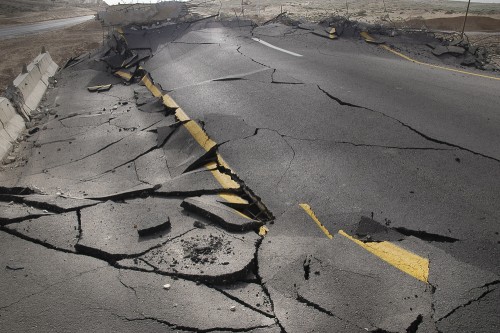 jor Cascade Faulty quake “would cripple the entire Pacific Northwest, from Northern California to British Columbia.” It projects that tens of thousands would lose their lives with many more injured. The major cities in the region could be devastated. The report says that across the pacific northwest “bridges, dams, roadways and buildings [would be] in a state of utter collapse. No water, electricity, natural gas, heat, telephone service or gasoline — in some cases, for months. Economic losses in excess of $30 billion.”
According to a summary of the recent scientific research (Massive earthquake threatens Pacific Northwest) in Communities Digital News:
“The Pacific Northwest is 71 years overdue for an immense 8.4 or larger earthquake, and tens of thousands of lives are at risk…. There have been only two comparable earthquakes in recent history. One was the 2011 Tohoku earthquake that damaged most of Japan’s east coast, killed 19,000 and destroyed the Fukushima Daiichi Nuclear Power Plant. The other was the 2004 Sumatra–Andaman earthquake that killed an estimated 230,000 in the Indian Ocean basin.”
The United States Geologic Survey (USGS) states that:
“Recent geologic findings indicate that earthquakes generated within the Cascadia subduction zone pose a significant hazard to urban areas of the Pacific Northwest. Evidence gleaned from syntheses of global subduction-zone attributes as well as from local tsunami deposits have been interpreted to suggest that great earthquakes have rocked the Pacific Northwest perhaps as recently as 300 years ago. Geodetic-leveling data indicate that a large patch of the interplate decollement (the main fault between the North American Plate and the subducting oceanic plate) off southern Oregon is locked. This and other evidence has led to proposals that an earthquake with a magnitude as large as 9 could someday devastate the region.”
The Cascadia Region Earthquake Workgroup calculated and summarized the disaster scenario of a major quake in their report “Cascadia Subduction Zone Earthquakes: A magnitude 9.0 earthquake scenario.” This reported scenario characterizes the effects of a major subduction earthquake on communities along the Cascadia Subduction Zone, stretching from the Brooks Peninsula on Vancouver Island to Cape Mendocino in northern California. This report is a “must read” for every disaster management and business continuity planner whether you are based in the U.S. pacific northwest or not.
- Video of Cascadia Fault Earthquake
- BBC Documentary of Cascadia Mega-Earthquake Threat
- Documentary video of Predicting the Pacific Northwest Mega-quake Disaster
Seattle Fault Zone
One of the associated fault lines related to the major Cascadia Fault is the Seattle Fault Zone. An earthquake on the Seattle Fault poses the greatest direct risk to the city of Seattle. The Seattle Fault Zone extends east-west through the very middle of the city. Quakes along this zone could be as large as magnitude 7.5.
Seattle Office of Emergency Management says that:
“An earthquake on the Seattle Fault poses the greatest risk to Seattle. Deep quakes are the most common large earthquakes that occur in the Puget Sound region. Quakes larger than 6.0Mm occurred in 1909, 1939, 1946, 1949, 1965 and 2001.
- The Seattle Fault zone extends east-west through the middle of the city.
- A Seattle Fault quake could be as large as magnitude 7.5, but less than 7.0 mm is more probable.
- The most recent Seattle Fault earthquake was about 1,100 years ago;
- The Seattle Fault has been active about three or four times in the past 3,000 years.
Megathrust earthquakes are the greatest risk to the region as a whole. A megathrust earthquake could reach M 9.0+ and affect an area from Canada to northern California. Shaking in Seattle would be violent and prolonged, but not as intense as a Seattle Fault quake. This area has a megathrust earthquake about every 500 years. About 15% of Seattle’s total area is soil that is prone to ground failure in earthquakes. The Duwamish Valley, Interbay and Rainier Valley are vulnerable to ground failure and shaking because of the liquefiable soils in these areas. Seattle has an estimated 819 Seattle unreinforced masonry buildings that perform poorly in earthquakes. These older brick buildings tend to be concentrated in areas expected to experience the strongest ground motion during earthquakes. Other vulnerable building types exist, too. Seattle is heavily dependent on its bridges. Damage to them would impair emergency services and the economy. The city has launched a multi-year effort to retrofit them to a life-safety standard so they won’t collapse. Despite the retrofits, many will not be usable after a strong earthquake. Most of the critical bridges were retrofitted by 2009.
Combined property damage for quakes in 1949 and 1965 in the region amounted to roughly $400 million (2010 dollars). The 2001 Nisqually Earthquake resulted in damage to City of Seattle buildings, infrastructure and response costs that exceeded $20 million. Adding in the costs of repairing arterial road structures, the figure topped $36 million. Secondary impacts such as landslides, tsunami, fires, and hazardous materials releases could become disasters themselves. In many earthquakes more people die from fire than building collapse. 2013 research finds that Seattle is at risk of thousands of landslides following a strong (magnitude 7) Seattle Fault earthquake. Estimates range from 5,000 if soils are dry to 30,000 if soils at saturated.
A large Seattle Fault earthquake could trigger a 16-foot tsunami that would strike the Seattle shoreline within seconds of the earthquake and flood it within 5 minutes. Although megathrust and deep earthquakes will not direct

ly cause tsunamis in Seattle these sources could initiate landslides that result in local tsunamis. A magnitude 7 Seattle Fault earthquake could cause dozens of fires. Suppressing the fires would be more difficult because damage to the water system would reduce water pressure in many parts of the city. Structural failure and fires would probably cause multiple hazardous materials releases. They could range from minor spills to major incidents.”
Seattle Natural Hazard Explorer
A new online application is available that allows individuals, businesses, schools, not-for-profits and pub
lic sector agencies to calculate their idiosyncratic risks (Predict Your Risk in Seattle’s Big Earthquake).
Vicky Gan writing in an article for CityLab reports that:
“[t]he Seattle Natural Hazard Explorer, an online tool recently released by the city’s Office of Emergency Management. Simply scan the maps or search for an address to see just how vulnerable you are to a range of natural disasters—not only earthquakes, but tsunamis, landslides, flooding and liquefaction, too. The maps give you a sense of the dangers at a glance, but you’ll have to drill down into the definitions to understand them and their potential impact on infrastructure. In the top map, the colors don’t correspond to the intensity of ground shaking per se; they indicate the percentage of the force of gravity that has a 10 percent chance of being exceeded in that area in 50 years. (Think of it this way: In order for an object to go flying, the force from shaking has to exceed the force of gravity pressing down on it.) In other words, if you live in a zone labeled 80 to 110 percent, then there’s a 10 percent chance that an earthquake will shake your house with between 80 and 110 percent of the force of gravity at some point in that 50-year period…. But don’t just use these maps to satisfy your morbid curiosity. Use them as a tool to get prepared for the big one.”
Preparedness Planning
If you are based or work in the pacific northwest region, it is essential to take steps now in order to achieve readiness for the coming “Really Big One.” Assess the risks to which you and your business are exposed from earthquake consequences. Initiate education and training efforts to build resilience and preparedness among your people. Take steps now for mitigation (including engineering and safety measures) and response planning. Connect to an early warning and alert network. Create, deploy and test a comprehensive emergency communication plan. Consider unique risks including dependence on key at risk infrastructure, vulnerabilities to Tsunamis or supply chain threats.
There are resources available to assist your preparation efforts. In addition, consider using subject matter experts to help ensure maximum readiness.
Are you ready for the “Really Big One?”
Suggested Links for Additional Reading:
http://www.oregon.gov/OMD/OEM/osspac/docs/Oregon_Resilience_Plan_Executive_Summary_Final.pdf
http://www.newyorker.com/magazine/2015/07/20/the-really-big-one
http://geology.about.com/od/quake_preparedness/a/aa_cascadiaEQ.htm
http://walrus.wr.usgs.gov/earthquakes/cascadia/
http://earthquake.usgs.gov/data/crust/cascadia.php
http://walrus.wr.usgs.gov/earthquakes/cascadia/
http://www.opb.org/news/series/unprepared/what-is-a-90-earthquake-/
http://seattlecitygis.maps.arcgis.com/apps/MapSeries/?appid=0489a95dad4e42148dbef571076f9b5b
 “What should we do now?” “What should we say?”